Have questions?
what is simTainment™?
request more information
Product Brochure
download now
-
- discover our unique selection of simTainment™ products for Microsoft Flight Simulator and X-Plane
- GTN 750/650 Touch™
- GNS 530W/430W V2™
- General Aviation T-Stack
- Analogue Navigation Gauges
- Wx500 XP™ Weather Radar
- See all
-
- combining traditional training and simulation expertise with novel approaches from the gaming industry to provide RealTime Training™
- RealTime Training™
- Microsoft ESP™
- See all
-
- we serve consumers, developers and enterprises helping deliver lowest overall cost and greatest competitive advantage
- Services we offer
- Industries we serve
- White papers
- About us
- top features
- closer look
- in depth
Fly WAAS Approaches
Like its real world counterpart, the GNS 430W XP comes with built-in WAAS navigation capabilities, and is capable to fly LPV “glideslope” approaches without reference to ground-based navaids of any kind. Featuring an advanced 15-channel receiver capable of five position updates per second, GNS 430W meets the FAA's stringent TSO C146a standards for WAAS "sole means" navigation — providing vertical and lateral approach guidance into thousands of U.S. airports previously inaccessible in IFR conditions.
Get High-Resolution Mapping
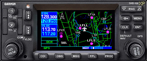
Effective use of color makes it easy to see your position relative to ground features, chart data, navaids, flight plan routings, approach procedures and more.
Put It on Autopilot
Working in tandem with the Microsoft Flight Simulator autopilot with a proprietary roll-steering command interface, GNS 430W XP behaves like a high-end flight management system (FMS) and can automatically fly your aircraft through holding patterns, procedure turns and other position-critical IFR flight procedures.
Enhance Situational Awareness
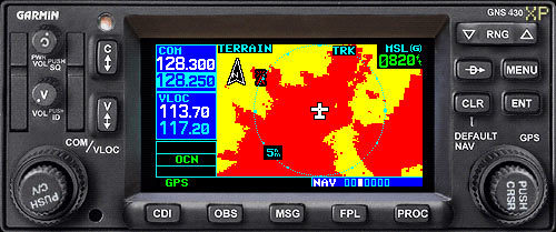
GNS 430W XP seamlessly integrates built-in terrain and navigation databases, providing a clear, concise picture of where you are and where you’re heading, using the Garmin Ltd. Trainer huge Jeppesen® database containing location reference for all airports, VORs, NDBs, Intersections, Flight Service Stations, published approaches, SIDs/STARs, Special Use Airspace and geopolitical boundaries. A detailed basemap clearly shows airports, cities, highways, railroads, rivers, lakes, coastlines and more. Using information from the built-in terrain and U.S. obstacles databases, the 430W XP displays color coding to graphically alert you when proximity conflicts loom ahead.